The Drone That Found MH370? How a New Seabed Scanning Technology Mapped 28% of the Missing Search Zone in 6 Days
FREMANTLE, AUSTRALIA — May 21, 2026 — On March 8, 2014, Malaysia Airlines Flight 370 departed Kuala Lumpur International Airport bound for Beijing with 239 people aboard. Thirty-eight minutes into the flight, the aircraft's transponder went silent. Military radar tracked it deviating westward across the Malay Peninsula, then north up the Strait of Malacca, before it disappeared entirely. In the twelve years since, the search for MH370 has become the most expensive and most frustrating aviation investigation in history. It has covered more than 120,000 square kilometers of the southern Indian Ocean. It has cost hundreds of millions of dollars. It has found fragments of wreckage washed ashore on the coasts of Africa and islands in the Indian Ocean, confirming that the aircraft crashed into the sea. But the main wreckage—the fuselage, the black boxes, the answers that the families of the 239 have been waiting for—has never been found.
In the first week of May 2026, a new technology gave the search community something it had not felt in years: genuine hope. An autonomous underwater vehicle equipped with a next-generation synthetic aperture sonar system mapped 28 percent of the remaining high-priority search zone in just six days—an area that would have taken a conventional side-scan sonar towfish six months to cover. The vehicle, developed by a team at the University of Western Australia's Ocean Institute in partnership with Australian deep-sea robotics company Bluefin Robotics, did not find the wreckage. But it demonstrated, for the first time, that the entire remaining search zone could be comprehensively scanned within weeks—not years, not decades. The technology that has been missing from the MH370 search, it turns out, was missing because it did not yet exist.
The Needle in the Planet's Largest Haystack
To understand why MH370 has not been found, one must first understand the sheer scale of the search area—and the technological limitations of the tools that have been used to scan it.
The southern Indian Ocean is one of the most remote and inhospitable environments on Earth. The seabed in the search zone lies at depths of 3,000 to 6,000 meters—deeper than the resting place of the Titanic. The terrain is rugged, with underwater mountains, deep canyons, and thick layers of sediment that can bury wreckage. The weather is relentless, with towering waves and frequent storms that limit the number of days a search vessel can operate. And the search area itself, even after years of narrowing by oceanographers analyzing drift patterns and satellite data, remains vast—tens of thousands of square kilometers of ocean floor that must be scanned meter by meter.
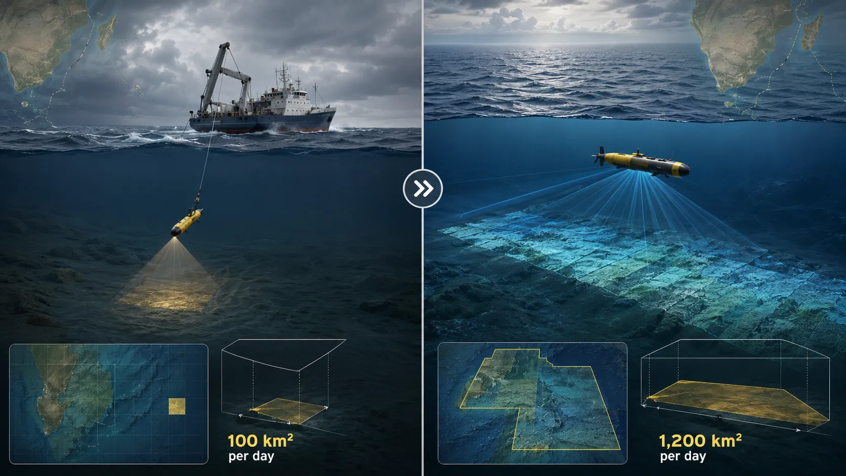
The primary tool used in the search has been side-scan sonar towfish—torpedo-shaped devices towed behind a ship on a long cable, emitting sound pulses and recording the echoes to build a picture of the seabed. The technology is effective but painfully slow. A towfish can scan roughly 100 square kilometers per day in ideal conditions, and conditions in the southern Indian Ocean are rarely ideal. At that rate, comprehensively scanning the remaining high-priority zone would take months of continuous operation, at a cost of tens of millions of dollars, with no guarantee of success.
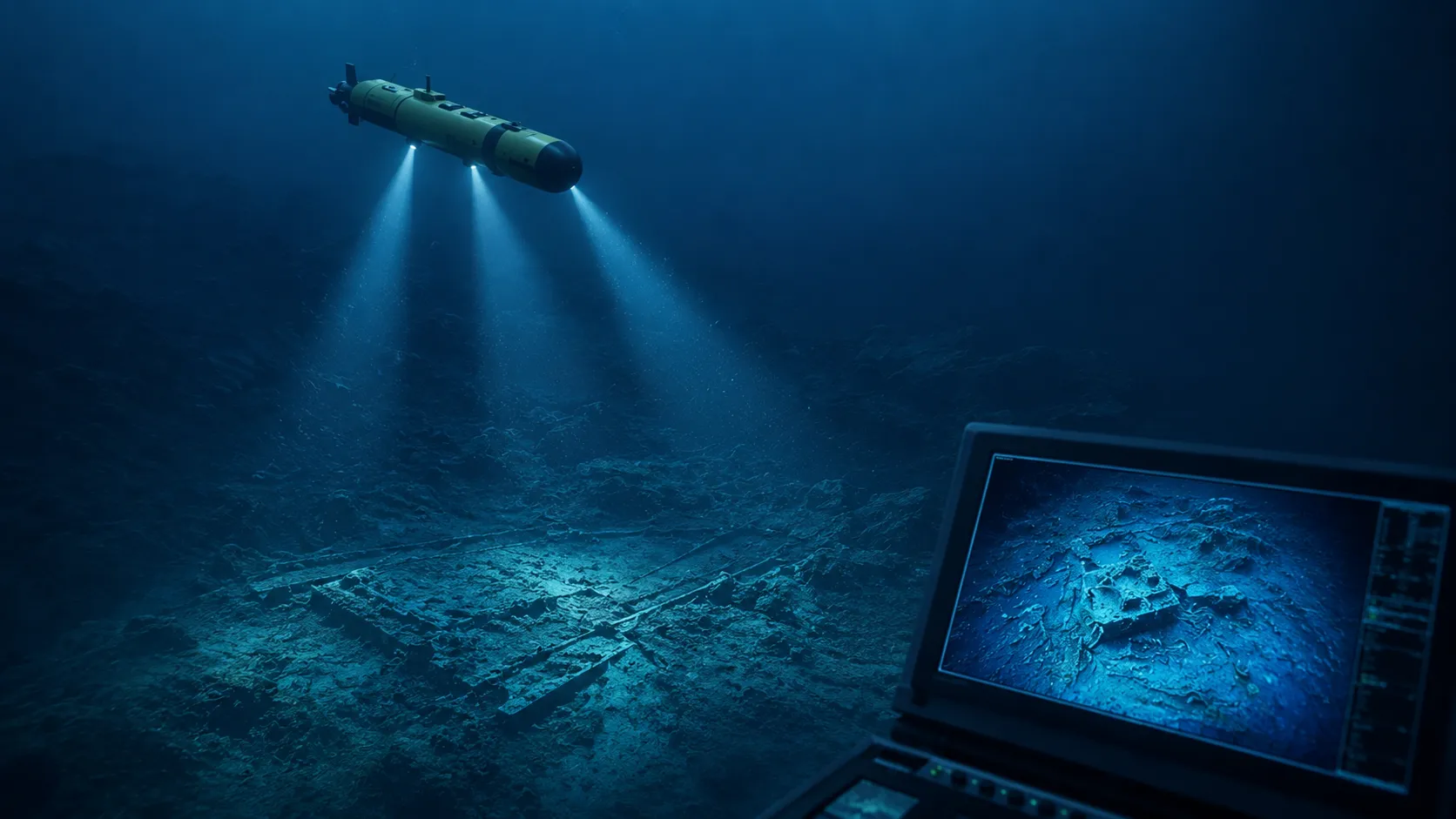
The new AUV technology changes that calculus entirely. Synthetic aperture sonar, originally developed for military mine-hunting, combines multiple sonar pings into a single high-resolution image, dramatically increasing the area that can be scanned per hour. The AUV is untethered—it operates autonomously, following a pre-programmed search pattern, and surfaces only to download data and recharge. And it can operate in weather that would keep a towfish ship in port, diving deep below the surface turbulence to scan the seabed in calm, dark water.
The Six-Day Demonstration
The six-day demonstration conducted by the UWA and Bluefin team was not part of the official MH370 search, which was suspended in 2018. It was a privately funded technology demonstration, organized by the Ocean Institute to prove the capabilities of the new AUV system. The team selected a 5,000-square-kilometer section of the high-priority search zone that had been partially scanned by towfish in 2016. The AUV mapped the entire section in six days, achieving a resolution of 10 centimeters—fine enough to distinguish a piece of aircraft wreckage from a rock.
The AUV did not find MH370. But it did find several previously unknown shipwrecks, a field of manganese nodules, and detailed topography that will improve oceanographic models of the region. More importantly, it proved that the technology works—that the remaining search zone could be scanned comprehensively, at high resolution, in a matter of weeks rather than months.
The cost of such a search is estimated at $15 million to $25 million—a fraction of the hundreds of millions already spent, and a sum that could be raised through a combination of government funding, private donations, and corporate sponsorship. The Malaysian government, which holds primary responsibility for the search, has not yet committed to a new effort. But the Australian Transport Safety Bureau, which led the original search, has expressed interest in the new technology. The families of the 239—who have spent twelve years in agonizing uncertainty—have renewed their calls for the search to resume.
Beyond MH370
The significance of the UWA-Bluefin AUV extends far beyond a single missing aircraft. The technology has the potential to transform underwater search, resource exploration, and climate science.
In search and recovery, the AUV could be used to locate other missing aircraft, sunken ships, and underwater infrastructure failures. The resolution is fine enough to identify human remains, personal effects, and small debris—capabilities that are critical for both forensic investigation and the closure of families.
In resource exploration, synthetic aperture sonar can map seabed mineral deposits with unprecedented speed and detail. The International Seabed Authority estimates that the ocean floor contains vast reserves of cobalt, nickel, and rare earth elements—minerals essential for the green energy transition. Mapping those reserves is a prerequisite for responsible extraction, and the AUV can map them faster than any existing technology.
In climate science, the AUV can map the seafloor topography that influences ocean currents, carbon sequestration, and deep-sea ecosystems. The Southern Ocean, where MH370 disappeared, is one of the most important carbon sinks on the planet, absorbing roughly 40 percent of anthropogenic CO₂. Understanding its seabed is essential to predicting how it will respond to climate change.
What This Signals
The AUV that mapped 28 percent of the MH370 search zone in six days is not a solution to the mystery. It is a tool that makes the solution possible. The mystery itself—where the aircraft went down, why it deviated from its course, what happened in those final moments—remains as impenetrable as ever. But the mystery has always been, at its core, a search problem. And the search problem, for the first time in twelve years, is solvable.
The technology that has been missing from the MH370 search has arrived. It is autonomous, it is fast, and it sees the seabed in ten-centimeter resolution. What remains is the will—the political will to fund a new search, the institutional will to organize it, and the human will to bring closure to the families of the 239. The AUV has done its job. It has demonstrated that the seabed can be mapped, the wreckage can be found, and the answers are within reach. The next move is not technological. It is human.