India's Deeptech Revolution Has an Unexpected Hero
When people think about India's technology success stories, they usually imagine software companies, fintech giants, SaaS startups, or artificial intelligence platforms. Few immediately think about maps. Yet maps — and the intelligence hidden within them — are becoming some of the most valuable digital assets in the modern economy. Every smart city project, infrastructure corridor, railway expansion, renewable energy park, industrial zone, and urban development plan depends on accurate geospatial data. And one Indian company quietly built an entire business around that reality.
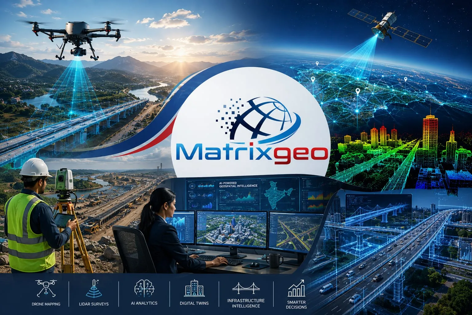
Matrix Geo Solutions began as a specialised geospatial services company operating far away from the spotlight enjoyed by consumer technology startups. Over the years, however, it transformed itself into a publicly listed deeptech enterprise working across drone mapping, LiDAR surveys, AI-powered geospatial analytics, digital twins, and infrastructure intelligence. Its evolution mirrors a larger shift taking place across India's innovation economy, where companies solving complex industrial problems are increasingly becoming as important as those building consumer applications.

The Business Most Investors Ignored
For decades, geospatial technology remained a highly specialised industry with limited public visibility. Unlike fintech apps or e-commerce platforms that interacted directly with consumers, mapping and surveying companies largely worked behind the scenes. Their clients were governments, utilities, telecom operators, infrastructure developers, and engineering firms. While the sector rarely generated headlines, it quietly provided the foundation for countless large-scale development projects across the country.
Matrix Geo Solutions built its expertise in precisely this environment. The company focused on capturing, analysing, and converting physical-world information into usable digital intelligence. Roads, buildings, utility networks, transportation systems, industrial assets, and land parcels became data layers that could be measured, visualised, and analysed. What appeared to be a mapping business on the surface was actually a sophisticated data business underneath. As India's infrastructure ambitions accelerated, the demand for this intelligence grew dramatically.
The Drone Revolution Changed Everything
One of the biggest catalysts for Matrix Geo Solutions' growth was the rapid adoption of drone technology across industries. Traditional surveying methods often required extensive manpower, significant time, and considerable expense. Large infrastructure projects could take months to map accurately, slowing planning and execution. As governments and enterprises sought faster and more precise solutions, drones emerged as a transformative technology capable of changing how geographic information was collected.
High-resolution aerial imagery suddenly made it possible to survey vast areas with remarkable speed and accuracy. Construction sites, highways, industrial facilities, power transmission corridors, mining operations, and urban development projects could now be monitored in near real time. Matrix Geo Solutions recognised this shift early and positioned itself at the centre of the opportunity. Rather than treating drones as standalone products, the company integrated them into a larger geospatial intelligence ecosystem that combined data collection, processing, analysis, and visualisation.

Why LiDAR Became a Competitive Advantage
If drones transformed the speed of data collection, LiDAR transformed the quality and precision of the information itself. LiDAR, which stands for Light Detection and Ranging, uses laser pulses to create highly detailed three-dimensional representations of physical environments. The technology can accurately measure terrain, buildings, roads, bridges, vegetation, utility assets, and entire cityscapes with a level of detail that traditional surveying methods often struggle to achieve.
For sectors such as transportation, mining, urban planning, defence, and infrastructure development, this accuracy is invaluable. Matrix Geo Solutions invested heavily in LiDAR capabilities at a time when relatively few Indian companies possessed the expertise needed to deploy the technology effectively at scale. That strategic decision helped the company move beyond conventional mapping services and enter higher-value segments of engineering support, infrastructure intelligence, and advanced geospatial analytics, creating a stronger competitive position in the market.
From Maps to AI-Powered Intelligence
The most important evolution in Matrix Geo Solutions' journey may not have been its adoption of drones or LiDAR. It was the company's transition from collecting data to interpreting it. Gathering geographic information has value, but extracting meaningful insights from that information creates far greater value. As artificial intelligence technologies matured, geospatial datasets became ideal inputs for machine learning systems capable of identifying patterns, anomalies, and opportunities that human analysts might miss.
Massive volumes of imagery, spatial information, and infrastructure data could now be analysed automatically and continuously. Risks could be detected earlier, assets could be monitored more efficiently, and decision-making could become predictive rather than reactive. Matrix Geo Solutions increasingly shifted its focus toward helping governments and enterprises turn raw geographic information into actionable intelligence. This marked its transition from being a mapping company to becoming a technology platform that supports smarter infrastructure and planning decisions.
Building India's Digital Infrastructure Layer
India's next phase of economic growth depends heavily on the successful execution of large-scale infrastructure projects. Highways, railways, industrial corridors, renewable energy parks, logistics networks, and smart cities all require accurate digital representations before construction begins. Once completed, those assets also need ongoing monitoring, maintenance, and optimisation. This growing complexity has created demand for technologies capable of bridging the physical and digital worlds.
One of the most important developments in this space is the rise of digital twins — virtual replicas of physical assets and environments that allow planners, engineers, and operators to simulate scenarios and improve decision-making. Matrix Geo Solutions has positioned itself as a key participant in this emerging ecosystem. By combining drones, LiDAR, AI, and advanced geospatial analytics, the company is helping create the digital infrastructure layer that increasingly sits beneath India's physical infrastructure ambitions, enabling smarter planning and more efficient asset management.
The Public Listing That Validated the Sector
Perhaps the most remarkable aspect of Matrix Geo Solutions' journey is not the technology itself but the recognition it received from public markets. Historically, infrastructure technology businesses often struggled to attract mainstream investor attention because their work was technical, specialised, and difficult for non-experts to understand. Consumer internet companies typically received greater visibility and higher valuations, leaving many industrial technology firms underappreciated despite their strategic importance.
Investor attitudes, however, are beginning to change. As governments prioritise digital infrastructure and deeptech gains greater prominence worldwide, specialised technology businesses are receiving the attention they deserve. Matrix Geo Solutions' successful public listing represents more than a corporate milestone. It reflects growing confidence in India's ability to build globally relevant deeptech enterprises beyond traditional software categories. The company's market journey signals that investors are increasingly willing to back businesses solving fundamental infrastructure and industrial challenges.

The Bigger Picture for Indian Deeptech
The rise of Matrix Geo Solutions illustrates a broader truth about India's innovation ecosystem. The next generation of transformative technology companies may not emerge solely from social media platforms, food delivery apps, or consumer commerce businesses. Increasingly, some of the most valuable opportunities are appearing in sectors that operate largely outside public attention. These industries often address foundational challenges that directly influence national productivity, competitiveness, and long-term economic growth.
Fields such as geospatial intelligence, advanced manufacturing, semiconductors, aerospace, defence technology, engineering software, and climate technology require deeper expertise and longer development cycles. They are often harder to build and more difficult to explain. Yet they also tend to create durable competitive advantages and significant barriers to entry. Matrix Geo Solutions demonstrates how companies operating in these sectors can build sustainable businesses by solving complex real-world problems that become increasingly important as economies modernise.
Looking Ahead
As India invests trillions of rupees into infrastructure, urbanisation, logistics, transportation networks, renewable energy projects, and smart city initiatives, the demand for geospatial intelligence is expected to grow significantly. Every major infrastructure project requires accurate digital information during planning, execution, and operation. Every large asset will need monitoring, optimisation, and predictive maintenance. Increasingly, every city will rely on data-driven decision-making to improve efficiency and quality of life.
This creates enormous opportunities for companies capable of transforming geography into intelligence. Matrix Geo Solutions began its journey by creating maps. Today, it is helping build the digital blueprint of modern India. In doing so, it represents a new generation of Indian deeptech companies that operate quietly but play a critical role in shaping the country's future. As infrastructure and technology become increasingly interconnected, businesses like Matrix Geo Solutions may prove to be among the most important innovation stories of the decade.